In November 2011 the Carrickabraghy Restoration Society commissioned an architectural analysis of the castle site from ARC Consultants. Segments of the report are reproduced here, by kind permission of the authors.
Outline of the history of Carrickabraghy and of the Upstanding Remains
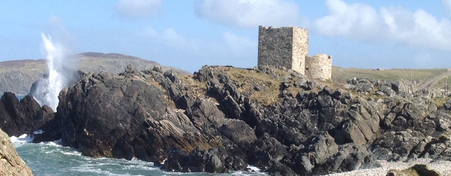
At present what is visible on the site of Carrickabraghy Castle are relatively recent remains. It is thought that the oldest section of what remains, that is the square keep, dates, at the very earliest, from the fifteenth century, but is, more probably, from the sixteenth century. As will be discussed below, other elements attached to it are probably more recent. However, Carrickabraghy is a very ancient place.
The antiquity of Carrickabraghy is evident from the name Carraig Bhrachaidhe, the rock of Brachaidhe, a personal name mentioned in the pre-Norman genealogy of Clann Fheargusa, a branch of the Cinél Eoghain. The Ó Maolfhabhaill (McFauls), lords of Carrickabraghy, mentioned many times in the Annals of the Four Masters, were considered important leaders in teh medieval world of the Cinél Eoghain. Between 835 A.D. and 1215 A. D. there are thirteen entries and all of them record the death of a Maolfhabhaill, lord of Carrickabraghy and occasionally interesting details are given concerning their deaths. Once such entry is that a major battle took place in 915 between the Uí Néill and the vikings in Munster in which over 1,000 men died. Another entry states that in 1102 a group from Inishowen made a raid to Magh Coba in Ulster in which Sitric Ó Maolfhabhaill was killed. The name Sitric would imply that the Vikings had intermarried and settled into the Ó Maolfabhaill family.
As well as the annalistic evidence, there is literary evidence from the period of the presence of the Vikings on the north west coast. A seventeenth century poem Ard na scéla, a mheic na gcuach, written by Flann Mac Lonain in 949 has references to marriage alliances and payments of tributes to the Vikings.
Further proof of Viking activity in the area is the concentration of finds of Viking Age silver in Inishowen. The hoards of arm rings found at different locations at Roosky, Carrowmore and Carrowen, were most likely deposited here during the 920s and 930s by their Irish owners, cf. Donegal: History and Society Chapter 4, Ó Floinn.
There is a map of the Inishowen peninsula dating from 1661, which is usually referred to as the Hollar Parsons Map. This map shows Carrickabraghy Castle in some detail. In fact, it is represented on the map at the same size as the Castle at Greencastle. Carrickabraghy Castle is shown as a square tower placed in the centre of a bawn, with the bawn surrounded by a bawn wall. There are a number of interval or mural towers shown in the bawn wall. Inside the bawn there appear to be the roofs of smaller buildings. Carrickabraghy Castle also appears on the Down Survey of 1655. It is probable therefore that, at the time, it was in the hands of a planted family following the Cromwellian plantation. this would explain the need for such elaborate fortification. AS will be seen below, there are some small fragments of the bawn wall and one of the mural towers still evident on site.
Carrickabraghy Castle appears on the first edition Ordnance map of 1834 where it is indicated as being in ruins. On that map there appears to be a walled area to the north of the tower with one other small structure within the walled area and a second small structure immediately outside the walled area at its southeastern side. There are two other buildings seen on the map in close proximity to the Castle lying to its southeast. The larger of the tow buildings, the one to the east, is in the same position as an existing two storey five-bay house, which is now referred to as the ‘Curate’s House’. This would indicate that the house dates from before 1834 and is, therefore, from the late Georgian period.
There are a series of stretches of Carrickabraghy Castle dating from 1802 and signed by Captain Sir William Smith. One of these is from the east and shows a length of bawn wall and an intact circular mural tower. Had the Curate’s House been in existence in 1802 it would have appeared in Sir William Smith’s sketch from the east. It is therefore reasonable to conclude that the house was built sometime between 1802 and 1834. In the following pages, three of Sir William Smith’s sketches are reproduced followed in each case by recent photographs taken from the same position.
On the Ordnance Survey map of 1848, the two buildings to the southeast of the Castle are still shown with the eastern one extending somewhat further to the east. An additional buiding appears directly south of the Castle. On the Ordnance map of 1900, the eastern building is shown extended even further to the east and the building south of the tower is shown extended northwards. This mapping information would suggest that the outbuildings to the east of the Curate’s House were gradually extended eastwards during the nineteenth century. It is not clear from the map what the building to the south of the Castle was when it first appeared on the 1848 map, though it was probably a small house. The extended form of that building seen on the map of 1900 would appear to be a range of cottages, which are at present, upstanding but in a ruinous condition.
Directly between the cottages and the Curate’s House, there is a small remaining section of the round mural tower seen in Captain Sir William Smith’s sketches of 1802. This has also been included in the recent topographical survey and rectified elevations of the inside and outside face are included below. What remains is a section of the wall of the tower rising about 1.5m out of the ground and about 3m in length. It follows what would have been the curve of the original round tower, representing about one fifth of the circumference. It has one small window opening visible mainly on the inside face, this opening being at the about one fifth of the circumference. It has one small window opening visible mainly on the inside face, this opening being at the present ground level. The fact that this opening is now at ground level would suggest that what is now the ground conceals further remains and that the origianl ground level was significantly lower. That the present ground level is higher than the original further remains and that the original ground level was significantly lower. That the present ground level is higher than the original is also clear at Carrickabraghy Castle itself, where lintels of what are clearly dooorways are only one metre or so off the ground.
It is intended to carry out archaeological investigation at the site. The site has, obviously, a complex history, there being references to Carrickabraghy as far back as 835. Whereas it may be desirable to carry out comprehensive archaeological investigation on the site, this is not the most urgent priority.
The elevated ground levels in and around the existing upstanding remains of the Castle and the mural tower are most probably the result of sections of wall collapsing and vegetation gradually growing over these collapsed sections. It is also clear from examination of the upstanding remains, that certain parts of the structures extended further than they do at present. It is, therefore, suggested that the priority for archaeological investigation should be in the area within and immediately adjacent to upstanding remains. the intention of such investigation would be to identify the form of built features which, though not visible over ground, may remain in part underground. Such archaeological investigation is also likely to recover stone fallen from the buildings. There is also a possibility that artifacts left by inhabitants might be uncovered.
The archaeological investigation within and around the buildings will result in the removal of fallen material and the exposure of foundations where these have been concealed. As well as being desirable for archaeological reasons, the removal of this material is essential for structural reasons. The upstanding remains are in places in a dangerous conditions and stabilising them is urgent. In order to stabilise them it will be necessary to find a firm footing on which any stabilisation works can stand.