Article by Richard Crumlish from McGlinchey Summer School Proceedings, Vol. 10
This talk was given as a tribute to eminent local historian and folklorist Conall Byrne (Richard’s uncle), who was due to deliver the talk but died suddenly in April 2007.
According to Joyce’s Place Names[1], ‘Doagh’ is a northern variant of the Irish word ‘Dumhach’ meaning a sand bank, which could be the source from which the isle derives its name. Even though today the Isle of Doagh is not an island, it may well have been at one time, probably following the retreat of the ice at the end of the last Ice Age approximately 14000 years ago. During this period as the ice melted the sea level rose flooding large areas of Northern Europe, including possibly the low-lying area across which one travels to access the Isle of Doagh from the main Carndonagh-Ballyliffen road. This rise in sea level is known as ‘eustacy’ and was followed by a rise in the level of the land known as isostacy, caused by the removal of the great weight of ice. The best evidence of this phenomenon is in the form of raised beaches and interestingly the two highest examples on the island of Ireland are located a short distance away from the Isle of Doagh at Ard Malin and Ballyhillin, Malin Head. In fact the raised beach at Ineuran Bay (Ardmalin townland) is visible from Carrickabraghy.
Amongst the earliest inhabitants of Ireland were those at Mount Sandel, a Mesolithic (Middle Stone Age) site excavated by Professor Woodman near Limavady in County Derry, dating to 7000 B.C. In Inishowen the Mesolithic is found in this parish (of Clonmany) at Dunaff, where evidence of flint working dating to 3500BC has been found[2].
The Isle of Doagh is perhaps best known in archaeological terms for its numerous examples of Rock Art, which dates to the Late Neolithic and Early Bronze Age, around 2000 B.C. It is usually found on exposed rock/rock outcrop and consists of various designs, such as cup marks, cup and circle motifs and concentric circles. Rock Art used to be known as Galician Art, as it is widely known in that north-west corner of Spain. It is also found in Portugal, Northumbria (England) and in Scotland. In Ireland the three main concentrations are found in West Cork/Kerry, Louth/Monaghan and in North Donegal. In Donegal the highest concentration of sites is in the Isle of Doagh, most of them in Maghernaul townland in the east and south-east of the Isle where a total of 42 examples have been recorded[3].

Carrickabraghy was one of three ancient sub-divisions of Inishowen prior to 1200 A.D. The other two were Breda in the E of the barony and Aileach in the S. Maghtochair translates the name as ‘the Friar’s Rock’[4]. We have a list of the lords of Carrickabraghy from 834 until 1198 in the Annals of the Four Masters[5], which is also referred to by Maghtochair:
‘In AD 834 the monarch Niall Caille led an army into Leinster; one of his officers, Fearghus, son of Badhbhchadh, lord of Carraig Brachaidhe, was slain by the Munstermen. Seghonnan, its lord, died in 858; Maelfabhaill, its lord, died in 878; Ruare, its lord, died in 907; in 915 its chief fell fighting, with the monarch Niall Glandubh, against the Danes; in 1014 Cudubh Ua Maelfabhaill, its chief, was slain by the Munstermen; in 1053 its lord died; in 1065 Maelfabhaill, its lord, was slain by OMeith; in 1082 its lord died; in 1102 Sitrick Ua Maelfabhaill, its lord, was slain; in 1166 Aedh, its lord, of same family, was slain by Niall Ua Lochlainn; in 1198 Cathalan O’Mulfavil, its lord, was slain by O’Dearan, who was himself slain immediately afterwards in revenge’.
The ruins we see at the site today were probably constructed in the 16th century A.D. The list of lords above, reprinted from the Annals of the Four Masters, suggest there may have been an earlier castle. Certainly Conall Byrne knew of two separate poems which suggested this. The castle at Carrickabraghy is one of five which remain standing in Inishowen. Four of these, including Carrickabraghy, are O’Doherty castles, the others located at Burt, Inch and Buncrana. The fifth is the large Norman castle of Northburgh at Greencastle. Northburgh castle was the largest castle ever built in the county and dates to the beginning of the 14th century. The O’Doherty castles were much smaller and later in date.
In 1600AD Carrickabraghy was occupied by Phelemy Brasleigh O’Doherty. Its most famous visitor was Sir Cahir O’Doherty, who arrived in late 1607, prior to his revolt, following the Flight of the Earls. In the years leading up to the Flight of the Earls, Sir Cahir was known as ‘The Queen’s O’Doherty’, having fought with Sir Henry Docwra in the Nine Years War, indeed he was foreman of the jury in Lifford which found the Earls guilty of treason (in their absence) following their exodus. There was a certain amount of paranoia on the English side following these events and Sir Cahir was amongst those Irish lords being closely watched in the aftermath of the flight in September 1607. From his own account he left Inishowen to cut wood near Kilmacrenan in late October 1607 for building operations at one of his castles. This departure was reported to the Lord Deputy, Sir Arthur Chichester, as evidence of rebellion and treason, i.e. that O’Doherty was on his way to Tory Island, there to await an army from Spain. On foot of this information, Sir George Paulet, the Governor of Derry, set out to arrest O’Doherty at Burt Castle but found Sir Cahir to be absent. Upon his return Sir Cahir wrote letters to Paulet and Chichester from Carrickabraghy in November of that year protesting his innocence[6]. Sir Cahir then went to Dublin to plead his case whereupon he was imprisoned in Dublin Castle for a number of days in December and only released on a recognisance of £1000[7]. Sir Cahir’s revolt began in earnest in April 1608 when he attacked Culmore Fort and subsequently captured Derry. He also captured Doe Castle and continued to move south through Ulster until the forces of the Crown began pushing him back. The decisive encounter occurred at the inauguration site of the O’Donnells, Doon Rock near Kilmacrenan, in July 1608 when Sir Cahir, still in his early 20’s was shot dead and there ended the revolt.
Following these events Sir Arthur Chichester was given most of Inishowen amounting to 170,000 acres (25,000 acres were given to the established church), as part of the Plantation of Ulster. Chichester leased Carrickabraghy to a Left. Hoan[8]. The castle was unoccupied by 1665.
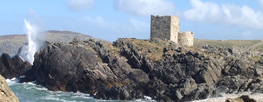
The site is known locally as ‘the Castles’. I believe this is because although what we see today is a single keep, the site originally would have consisted of the keep located within a bawn wall along which were a number of towers. This is what is shown on a sketch included in the Ordnance Survey Memoirs from 1833-5[9]. Carrickabraghy has a strategic location with a panoramic view and is easily defended, being located on a promontory surrounded by water on three sides.
The earliest surviving phase of construction at Carrickabraghy is the keep, which is built of rubble and dates to the 16th century[10]. Unfortunately no evidence remains of the doorway which would have been located in the east wall. On the ground floor are two window openings, that in the north wall having been reconstructed and a wall-press in the interior of the west wall. Three opposing holes for joists for the timber floor are visible between the ground and first floor. The first floor has window openings in three walls, a doorway and intramural staircase to the second floor. The Ordnance Survey Memoirs[11] describe a fireplace in the west wall but this is not now visible, certainly from ground floor level.
The second phase, probably dating to the 17th century, is the bawn wall and two towers. The tower is tied into an east/west wall which would have extended across the promontory. The surviving section of the east/west wall has a doorway from which its lintel has fallen and a draw-bar hole. The tower is not tied into the keep, suggesting a later date. The tower contains three gun loops and a doorway with draw-bar hole. The second tower is just visible to the south-east as a pile of rocks[12].
The third phase, which probably dates to later in the 17th century, is evidenced by a second wall, probably built by Hoan, which is not tied into the east/west wall. This was a defensive addition at the site to close in the keep and the adjacent tower[13]. This wall contains two gun loops and possibly a doorway at its northern end.
Recent plans by the McGlinchey Summer School committee to explore ways to conserve this important monument are to be complimented and encouraged.
Richard Crumlish, B.A., H.D.E., M.I.A.I..
[1] Joyce, P.W. Irish Names of Places, Dublin, 1869
[2] Lacy, B. (Ed.) Archaeological Survey Of County Donegal, Lifford, 1983
[3] Lacy, B. (Ed.) Archaeological Survey Of County Donegal, Lifford, 1983
[4] Maghtochair Inishowen, Its History, Traditions and Antiquities, 2nd Edition, Carndonagh, 1935
[5] AFM Annals of the Kingdom of Ireland by the Four Masters, from the earliest period to the year 1616, 7 Vols., Third edition, Dublin, 1990
[6] Bonner, B. That Audacious Traitor, Dublin, 1975
[7] McCavitt, J. Sir Arthur Chichester, Lord Deputy of Ireland 1605-16, Belfast, 1998
[8] Lacy, B. (Ed.) Archaeological Survey Of County Donegal, Lifford, 1983
[9] Day, A. and McWilliams, P. (Eds.) Ordnance Survey Memoirs of Ireland, Parishes of County Donegal 1, 1833-5, Belfast, 1997
[10] Lacy, B. (Ed.) Archaeological Survey Of County Donegal, Lifford, 1983
[11] Day, A. and McWilliams, P. (Eds.) Ordnance Survey Memoirs of Ireland, Parishes of County Donegal 1, 1833-5, Belfast, 1997
[12] Lacy, B. (Ed.) Archaeological Survey Of County Donegal, Lifford, 1983
[13] Lacy, B. (Ed.) Archaeological Survey Of County Donegal, Lifford, 1983